Welch Comer delivers better topos faster with Mach9
Drone LiDAR topographic surveys across the Inland Northwest

[I] can go capture a bunch, get it processed, and know it's sitting there at 80%. Before, it'd be processed and that's it. There's no linework. There's nothing extracted yet.

A Multi-Tool Extraction Workflow Slowed Topo Delivery and Tested Trust in Drone Data
Now it's basically all I use. Once TINs dropped, I don't need to open another software. Everything's in Mach9 until I bring it into CAD, which is super useful. I was previously using three to four different software at times, just depending on what I wanted to visualize.
With offices in Coeur d'Alene, Idaho, and Liberty Lake, Washington, Welch Comer Engineers serves cities, water and sewer districts, and state transportation clients across the Inland Northwest. Thomas Tucker, Survey Project Manager, leads the firm's reality capture program.
Welch Comer has used drones for over a decade, at first only to produce background imagery for CAD drafting. Thomas took over the program six years ago, did research on photogrammetry, and upgraded the drone program to extract topographic maps directly from point clouds. Last year, the firm upgraded to a newer drone with an aerial LiDAR sensor, which expanded their flying ability but also the volume of data that they needed to extract.
That extraction had to be spread across multiple tools; one was better at soft breaks, a second was better at curbs, and a third let them build the final surface. Their big struggle: managing and combining data from across all of these disparate sources, and tracking down inconsistencies and crossing breaklines when they finally merged all of their extraction.
Worse was the trust issue. The drone program was new at Welch Comer, and engineers that were used to field-surveyed data needed to be convinced to trust these new deliverables. Any small error risked making the whole drone program look like a problem.
Thomas was looking for a solution; he'd tried almost every software on the market to extract, but every time, the software just wasn't worth investing extra time into learning. But Mach9 was different: "Right away with Mach9, it was like 'wow, no, this one's cool'. This one saves time."
One Platform from Point Cloud to Design-Ready Linework and Surfaces
Welch Comer started using Mach9 in the spring of 2026, right at the height of capture season. The Mach9 customer success team kept him moving, and with a steady stream of flights to work through, Thomas quickly worked Mach9 into their production workflow.
Today, projects at Welch Comer run through Mach9 end to end. First, Thomas flies the site, processes the collected data in the drone's native software, and prepares it in Trimble Business Center. He then uploads the data to Mach9 and requests automation right away. For most sites that Welch Comer flies, their capture-to-office process fits in a single day; by the next morning, Mach9 has drafted initial linework across the entire area.
From there, Thomas focuses on refinement. He corrects the areas that need expert judgment, extracts objects such as manholes, signs, and poles, and checks the generated surfaces directly against the point cloud. Instead of having to bounce between tools, he can perform his entire extraction workflow inside of a single software.
A lot of flights and sites we fly, [we] can get that in one day. So by the next morning after I captured it, we have linework on the whole area.
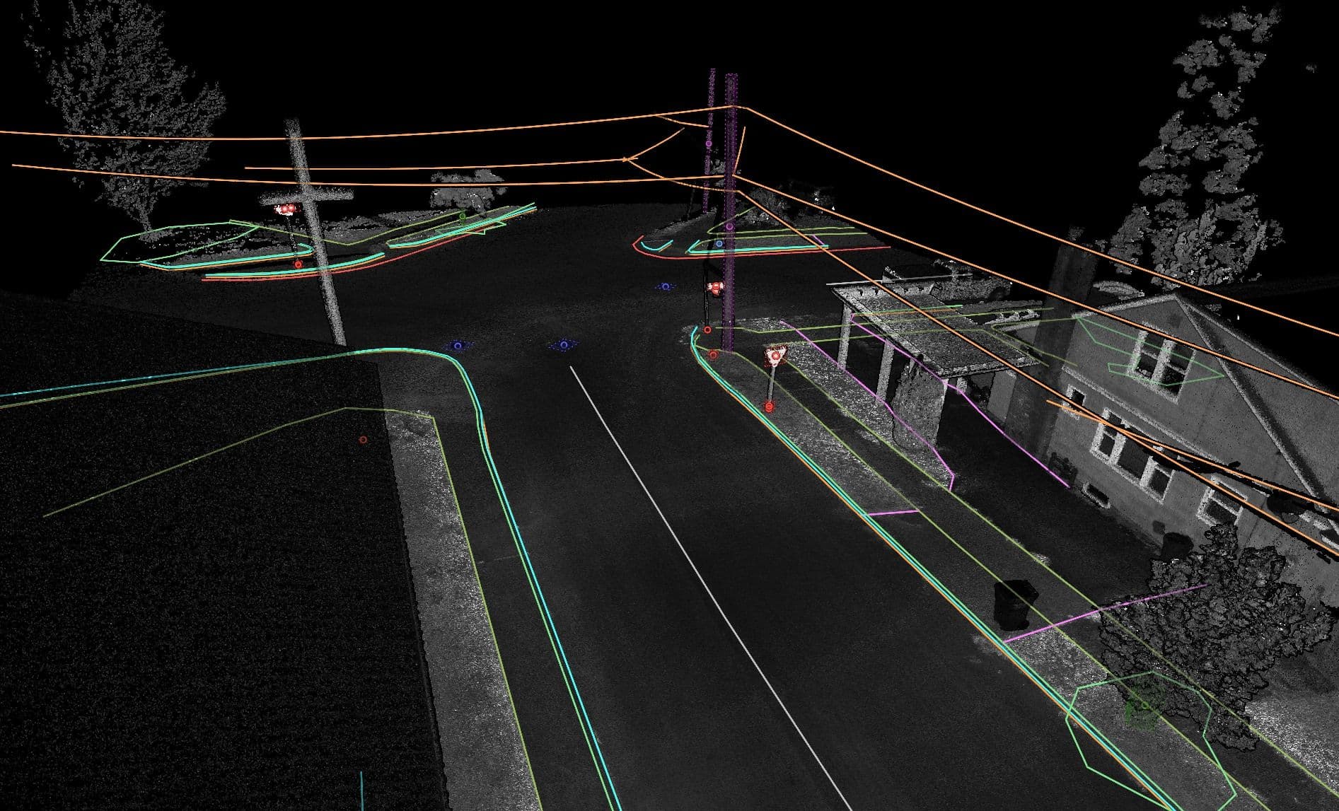
Welch Comer captures many of the same features project to project. Mach9's templates feature helped align the automation output with the firm's standards. "It helped me understand the program: what does it do, and what do I want it to do?" Thomas says.
Mach9 helps once the initial extraction has been completed, as well. Engineers often go back and ask for more data; if the original drone capture also captured the new region, Thomas can easily continue extracting directly on the same data in Mach9. "Boom, you have your additional 40 feet on the north end of the project."
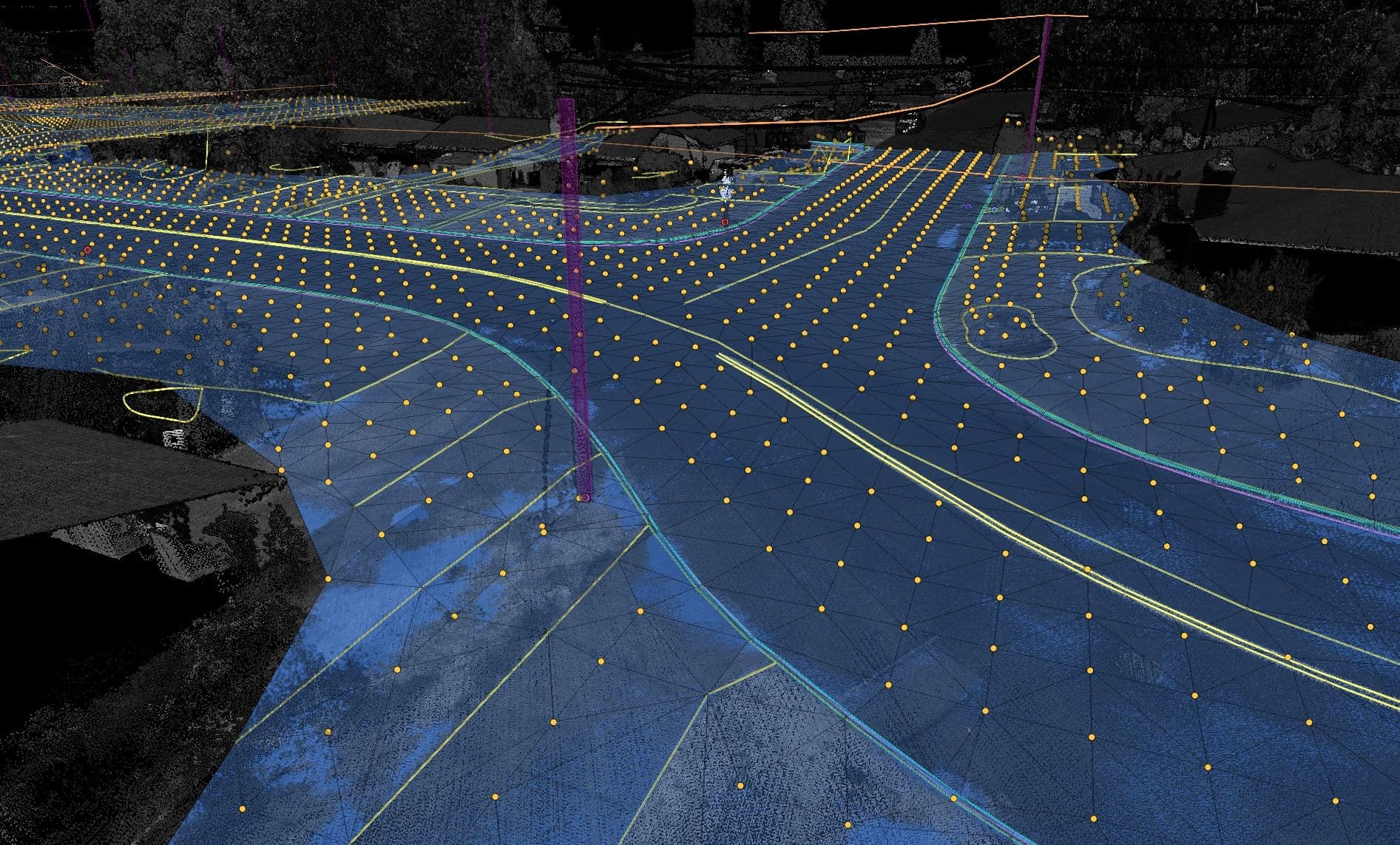
Thomas has seen Mach9's solution improve even more since he first started working with the software. Mach9 shipped TIN modeling of surfaces at the end of July with extensive customer feedback; an extra breakline check landed within about a month of Thomas asking. "You buy software, but then three months later, you have a completely different one, in a good way," he says.
Welch Comer Delivers Better Topos Faster and Stays Ahead of The Market with Mach9
Mach9 lets Welch Comer replace a complex, multi-software extraction process with a single solution that takes their drone and LiDAR data all the way from capture to extracted linework. Thomas has seen both speed and quality gains on his projects: "It might save a day and be better. That's a win-win."
Mach9's impact reaches beyond just individual projects. Welch Comer's early investment in mobile SLAM scanning and aerial LiDAR makes it a technology leader in its region. Thomas sees Mach9 as the next step in that strategy, covering "the most important part of the workflow": turning a point cloud into something usable. By investing in better technology like Mach9, Welch Comer has won several recent projects. As Thomas says, "If it blows my mind, it's going to blow someone else's."
Looking ahead, Welch Comer plans to keep growing their aerial LiDAR program. Using advanced software like Mach9 is key to their strategy to protect their returns on investments:
Eventually the market will normalize as other firms invest in this technology [LiDAR scanning hardware]. Mach9 is going to keep us efficient, so we're not losing money on any of these investments.

Welch Comer is a 100% employee-owned engineering firm serving communities across Idaho and Washington since 1979. From offices in Coeur d'Alene, Idaho, and Liberty Lake, Washington, the firm provides municipal engineering, transportation, water, wastewater, master planning, surveying, and parks and recreation services to municipal, state, federal, and select private clients. Welch Comer's work has been recognized by the American Council of Engineering Companies (ACEC), including an ACEC Washington Gold Award for the Pullman Downtown Revitalization Project.

Mach9 is AI CAD software for civil engineering, starting with surveying. It turns reality capture data into engineering-ready CAD deliverables with AI-assisted feature extraction. Teams review and edit the output in Mach9, then export to Civil 3D or MicroStation.
More case studies
See all →


Turn weeks of drafting into hours

Mach9 shaves weeks and weeks off extraction on our civil corridor projects. We can fly through vertices and line work in 3D — half our data is already done before we start verifying.”
A recurring theme in the civil engineering industry is how difficult it is to find trained technicians. Mach9 enables us to do 50% more work with the same experienced team. That's extremely important for us.”
Mach9 changed how our team works. The time we used to spend on manual feature extraction, we now spend on parts that require expert judgment, like resolving edge-case geometry.”
With Mach9, we now have a state-of-the-art feature extraction workflow. Instead of spending hours tracing objects in a point cloud, we directly review Mach9's AI-generated assets.”
One of the best things about Mach9 is that you get immediate value without any learning curve. The feature extraction is super accurate, and you go from point mapping to a design-grade deliverable seamlessly.”
The ability to perform full QA in a single interface, without jumping between systems, has transformed how we approach statewide inventories. Mach9 brought consistency and confidence to our data workflows.”
Director of Reality Capture, Feldman GeospatialRob Ashley
HDLS Technology Director, PennoniEddie Fossler
VP & Quality Management Leader, OlssonKaty Sprenger
GIS Specialist, TruenetDiana Wohlfarth
PennoniJeff Tornatore
Project Manager, Michael Baker International
Step 1 of 3